
Features vTools Survey - GPS Mapping
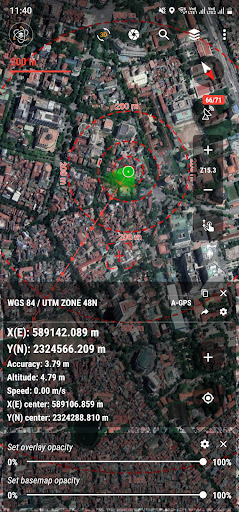
Function of application:- Positioning, current position, practical view angle in the field.
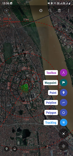
Help identify better directions.- Allows users to directly create objects (Points, Lines, Polygons, Coordinate Waypoints, Tracklog routes).- Allows rapid measurement of the area and length of objects in the field.- Users can simultaneously create Tracklog, Point, Line, and Polygon at the same time while moving.
Tracklog mode allows running in the background.- Support to save attribute information and images in the field.- Users can define forms fields to collect.
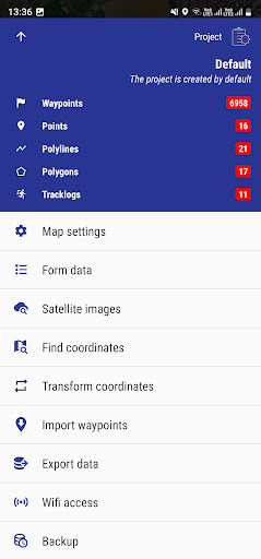
And share quickly to the whole group via QR code or export to file.- Find for waypoint, enter a list of waypoints from data TEXT(*.txt), Excel (*.xls, *.xlsx), CSV (*.csv) Excel and convert point coordinates directly on the device.- Allow to enter the list of points to check by hand (For example, it is necessary to check the location of the extract of the red book).- Support directly opening common data such as Excel, GPS/GPX, KML/KMZ, GeoJSON, AutoCAD DXF, MicroStation DGN, ESRI Shapefile SHP, MapInfo TAB, gCadas GTP, GeoTIFF, JPG, PNG- Support export data to GPX, KML, GeoJSON, Excel, AutoCAD DXF, MapInfo TAB, Shapefile SHP format and share via Email, Drive, Zalo, Facebook etc.- Fully support the VN 2000 projection system of the local and nationwide of Vietnam.- Support more than 5000 projection systems of other countries and territories in the world.- Support for old projection systems like Hanoi 1972 (HN 72).- Support numerical compass feature- Support reading offline map data MBTiles and intelligent management of data layers.- Support with simple MBTiles convert tool on Desktop, help to view properties directly from MBTiles layer.- Support conversion of TCVN3, VNI encoding for Vietnamese font in viewing attribute information.- Support field photography, save location, shooting direction on images and Exif information, GeoTag- Allow users to download Google, MapBox, Bing, ESRI, OSM directly on the computer for offline use.- Support web map service TMS and WMS.- The feature allows users to directly find and use Landsat 8 satellite image data (16-day update cycle) and Sentinel 2 (5-day update cycle) from the image database.- Location view feature with 3D perspective with global elevation digital model.If you need assistance please contact us at the following information:Facebook: https://www.facebook.com/vToolsForMapInfoEmail: [email protected] (Zalo, WhatsApp, Viber, Telegram): (+84) 96 990 4596Website: https://apps.vtools.xyzYoutube: https://www.youtube.com/c/vTools/playlistsAll Rights Reserved.
Copyright © vTools Apps
Social Features
Connect and share with friends and the community.
Gaming Features
Enjoy immersive gaming experience with various game modes.
Camera Features
Advanced camera features with editing capabilities.
See the vTools Survey - GPS Mapping in Action
Get the App Today
Available for Android 8.0 and above